The Maine Weather Podcast

The Maine Weather Podcast

by The Weather Podcast, Inc.

Maine Weather 3/9 Midday - Winter Storm Watch

Advisory in effect for northern and northern Maine. midday Mon Mar 9th, 2026 Maine forecast.

Maine Weather 3/9 Morning - 22° Above Normal

Advisory in effect for northern and northern Maine. morning Mon Mar 9th, 2026 Maine forecast.

Maine Weather 3/8 Evening - Rain

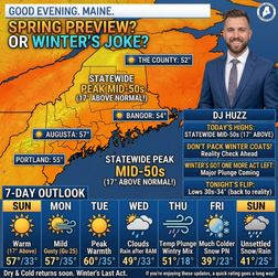
Good evening. Maine. I'm DJ Huzz. The weather's playing a joke on us today. Step outside and you'll swear it's April. We're hitting the mid-50s statewide — that's 17 degrees warmer than normal for early March. Portland peaks near 55. Augusta climbs to 57. Bangor reaches 54. Even The County hits 52. This is the kind of warmth that tricks you into packing away your winter coat. Don't fall for it. Tonight we slide back to reality. Lows drop to the low 30s under mostly clear skies. Portland settles at 33. Augusta cools to 34. Bangor falls to 30. Light southwest winds around 5 to 10 miles an hour. Monday keeps the mild streak alive. Highs climb back to the low-to-mid 50s. Portland hits 57. Augusta reaches 53. Bangor tops out at 55. Mostly sunny, but southwest winds pick up — gusts to 25 miles an hour. Monday night lows dip to the mid-30s. Tuesday brings the warmest day of the week. Highs push into the upper 50s across the board. Portland reaches 59. Augusta hits 60. Bangor climbs to 59. Sunny skies dominate. Light winds. Tuesday night lows settle in the mid-30s. For the rest of the week. Wednesday brings clouds and rain, especially after 8 A.M. Highs in the mid-40s to low 50s. Thursday turns active — rain likely, some heavy, with a wintry mix possible inland. Then a cold front crashes the party. Temperatures plunge fast. Thursday night drops to the teens and low 20s. Friday turns much colder. Highs only reach the upper 30s to low 40s. Another system rolls in Friday night into Saturday — snow and rain possible. The weekend stays unsettled with temperatures closer to normal. Enjoy the spring preview while it lasts. Winter's got one more act left. See you tomorrow.

Maine Weather: 03-08-2026 Midday

Maine weather update for midday

Maine Weather: 03-08-2026 Midday

Maine weather update for midday

Maine Weather 3/8 Midday - Rain Starting 9 AM

Good afternoon. Maine. I'm DJ Huzz. Spring just showed up early for a test drive. Step outside right now and you're already feeling mid-40s. By this afternoon? We're hitting 57 degrees across most of the state — that's 17 degrees warmer than normal for early March. Not complaining. Down in Portland, you've got some patchy fog and drizzle wrapping up by mid-morning. Then partly sunny skies take over with a high near 54. Southwest winds gust to 25 miles an hour — enough to remind you it's still March. Central Maine sees similar action — Augusta and Waterville hit 57 after some early rain clears. Up in Bangor, scattered showers stick around through late morning before the sun breaks through. You top out at 56. Along the coast and Downeast, it's a touch cooler with more clouds hanging on. Highs reach the upper 40s to low 50s. The Western Mountains see partly sunny skies after early fog burns off, topping out near 48. The County gets patchy fog and scattered showers through midday, with highs near 47. Tonight, mostly clear skies settle in statewide. Lows drop to the low-to-mid 30s — mild for early March. Here's your heads-up for the week ahead. Monday stays mild with mostly sunny skies and highs in the low 50s. Tuesday brings even more warmth — upper 50s to near 60 degrees. Gorgeous spring-like conditions. But Wednesday flips the script. A storm system brings rain, with a chance for mixed precipitation up north. Thursday sees rain likely statewide with a strong cold front sweeping through. By Friday, highs crash back to the upper 30s to low 40s with a chance for snow showers. Saturday stays chilly with lingering snow chances. One more thing — clocks spring forward tonight. You lose an hour of sleep, but we gain daylight. Sunrise tomorrow is at 7:07 A.M., sunset at 6:39 P.M. Enjoy the warmth while it lasts. See you this evening.

Maine Weather 3/8 Morning - Rain Starting 3 AM

Good morning. Maine. I'm DJ Huzz. Step outside right now and you might forget it's still winter. We're sitting at 46 degrees after an overnight low of 39. That's 16 degrees warmer than usual for early March. And it feels like spring decided to show up early. Today pushes us to 56 degrees under partly sunny skies. Those patchy showers and fog? They'll clear out by late morning. Southwest winds gust to 25 miles an hour, so hold onto your hat if you're out for a walk. Tonight drops back to the low 30s statewide. Clear and calm. Monday keeps the warmth rolling. Portland hits 54. Bangor reaches 52. And even The County climbs to 49 under mostly sunny skies. Southwest breezes gust to 25 again. Tuesday is the star of the week. Sunshine pushes the coast near 60 degrees. Augusta tops out at 62. Bangor hits 60. And the mountains reach the mid 50s. This is as good as it gets. Then Wednesday flips the script. A storm system swings in from the Great Lakes bringing rain statewide. The County could see a mix of sleet and freezing rain as cooler air filters back in. Highs only reach the low to mid 40s. Thursday stays wet with rain likely and highs in the upper 40s to low 50s. Behind that system, temperatures crash Thursday night into Friday. We're talking single digits and teens in the mountains, low 20s along the coast. Friday brings sunshine but much colder air. Highs struggle to reach the upper 30s to low 40s. One quick note. Spring forward tonight. Set those clocks ahead one hour before bed. See you this afternoon.

Maine Weather 3/7 Evening - Foggy, Frosty, Fabulous!

Good evening. Maine. I'm DJ Huzz. Step outside and you’ll feel that familiar raw dampness in your bones. We’re sitting at 39 degrees under a stubborn gray overcast. It feels colder than the thermometer says, folks. But here’s the surprise — we’re actually winning today. Today’s high hits 43 degrees, which is 11 degrees above normal for early March. Spring is definitely trying to kick the door down. Down along the coast. Portland is holding at 43 degrees with a light south wind at 10 miles an hour. Don’t let the sun fool you; it feels like 32 with that damp air settling in. You’ll see drizzle after 9 PM, then steady rain moves in between midnight and 5 AM. Temperatures actually rise overnight, climbing from 40 to 47 by dawn. Head inland to Augusta and Waterville. And patchy fog develops this afternoon with highs near 40. That fog lingers into the evening before rain takes over after midnight. Like the coast, lows start in the upper 30s then warm into the mid-40s by Sunday morning. Bangor and the Penobscot region are seeing fog and a slight chance of rain this afternoon at 41 degrees. Rain becomes likely after 9 PM with lows around 36, rising to 43 by morning. Over in the Western Mountains, it’s mostly cloudy at 43 degrees with a slight chance of rain today. Look for drizzle tonight with lows around 39, warming to 47 overnight. Up in The County, it’s gray with highs around 40. Rain becomes likely tonight as temperatures rise from 36 to 42 by morning. The Midcoast and Downeast follow the same pattern — fog today, rain tonight. And temperatures climbing from the mid-30s to around 43. In Here’s your heads-up for week ahead, sunday brings a break with partly sunny skies and highs in the 50s. Monday and Tuesday get even warmer — we’re talking upper 50s to near 60, potentially record-breaking warmth. But Wednesday brings a system change — clouds move in with rain likely and highs dropping back to the 40s. Thursday stays wet with rain mixing to snow up north. Friday clears out but cools down significantly into the 30s. This warmth is going to decimate our snowpack. Southern Maine might lose it all, while the north holds onto patches in the shade. And with Maine Maple Sunday just 8 days away, this warmup could get those sap buckets flowing early! We’re gaining daylight fast, too — nearly 3 minutes every day. Sunrise was at 6:09 AM. And we’ll see sunset at 5:38 PM. Grab your umbrella before you head out tonight. You'll need it. See you tomorrow.

Maine Weather 3/7 Midday - Spring Sneeze in March

Good afternoon. Maine. I'm DJ Huzz. Step outside today and you'll feel that classic early-March battle. Spring is trying to push winter out the door, but winter isn't leaving without a fight. Portland is sitting at 43 degrees right now, already running 11 degrees warmer than usual. You'll notice a breeze at 10 miles an hour, gusting to 25, shoving that mild air inland. Head up to Bangor. And it’s a touch cooler at 41 degrees. You might see some light rain this afternoon, though it's only a slight chance. The wind is really howling there, gusting to 23 miles an hour — hold onto your hat. Over in the Western Mountains, you're at 43 degrees with just a after 5 PM. Down east, the ocean keeps things damp at 40 degrees, with fog rolling in off the water. In Here's surprise tonight, temperatures actually rise while you sleep. Portland drops to 40 this evening, but climbs back to 47 by sunrise. Rain moves in between midnight and 5 AM. It's the same story in Augusta, rising from 39 to 45 overnight. Bangor warms from 36 to 43 by morning with rain likely. Even the Western Mountains climb from 39 to 47. This isn't your typical freeze — we're thawing fast. Sunday brings a real spring tease. Portland hits 54 degrees — a solid 14 degrees above normal. Augusta hits 56. Bangor reaches 55. And the mountains get to 48. It will feel like a gift. Looking ahead. Monday and Tuesday stay unseasonably warm, near 60 degrees. But Wednesday brings a wildcard. A storm moves in. And confidence is low on who gets rain versus snow. Northern Maine has the best shot at seeing sleet or snow, while the coast likely sees rain. By Friday, we cool back down, but this warmth will decimate the snowpack. If you're heading to the coast, watch for dense fog this afternoon. Visibility could drop fast. See you this evening.

Maine Weather 3/7 Midday - Foggy Pea Soup Day

Good afternoon. Maine. I'm DJ Huzz. Step outside and you'll feel that unmistakable early March dampness. We're sitting at 38 degrees under a gray sky this morning. But Portland is climbing to 45 degrees today. That's 11 degrees above normal. And with maple sugaring season just 8 days away, this warmth is melting our snowpack fast. The state is having two different days today. Down along the coast. Here comes a foggy, damp afternoon near 45 degrees. That south wind at 10 miles an hour pulls in mild air, but it feels raw. Head inland to Augusta. And you top out at 41 with areas of fog. But up north? that's where the wind takes over. Bangor sits at 41, but gusts to 23 miles an hour make it feel colder. And in The County, you're lucky to hit 40 with that wind howling at 16 miles an hour. Tonight is where things get interesting. That mild air wins the battle. Temperatures actually rise after midnight. Portland climbs from the 30s to near 47 by sunrise. But rain moves in statewide after 10 PM. It starts as drizzle, then turns steady by midnight. Northern Maine could see up to a quarter-inch of rain. With that deep snowpack, we're watching for potential ice jams on the rivers. Sunday brings a serious warm surge. Highs hit the 50s—53 in Portland, 55 in Augusta. And 56 in Bangor. That's 15 degrees above normal. Monday and Tuesday stay downright spring-like, flirting with 60 degrees. But winter isn't done yet. A storm rolls in Wednesday. Right now, rain looks likely for most of us, but up north you could see sleet or snow mixing in. By Friday, we're back to the 30s and 40s. This is the mildest stretch we've seen in months. But don't put the shovel away just yet. If you're tapping trees next weekend, you might be doing it in a raincoat. See you this evening.
29 of 34